King County’s search and rescue teams are begging hikers to stop making the same dangerous mistakes
The call came in around 4 p.m. Dehydration. Severe leg cramps. A hiker who couldn’t move.
It was the fifth rescue in seven days on the same trail.
King County Explorer Search and Rescue volunteers grabbed their gear and started the brutal climb. Again. Over a dozen volunteers hiked more than 3,000 feet of elevation gain to reach the stranded hiker. On the way up, they found several other hikers stumbling around in the dark, relying on dying phone flashlights, completely unprepared for what they’d gotten themselves into.
This wasn’t an isolated incident. This is a pattern.
One Trail. Hundreds of Rescues. Zero Lessons Learned.
Between June 14-20 alone, King County SAR responded to five separate distress calls on a single hiking trail less than an hour from Seattle. Seattle Mountain Rescue added three more calls on June 19. By mid-year, the volunteer teams had already logged nine rescue missions at this location. In 2025, this trail consistently ranks in the top five most common rescue spots in King County.
The proximity to Seattle creates a dangerous illusion. People see it on Instagram. It’s right there off I-90. How hard can it be?
Really, really hard.
According to King County SAR spokesperson Natalie Patterson, most rescue calls involve dehydration, leg cramps, falls, and people getting caught after dark. But the underlying issue? Hikers treating a brutal mountain ascent like a casual afternoon walk because it’s close to the city.
“What this tells us is that hikers may not be doing enough research on just how hard they are,” Sara Autio from King County SAR told local media. “These aren’t hikes to try unprepared.”
The trail is so notorious that King County SAR semi-seriously posted on Instagram they’ve “Officially Filed Change of Address to Mailbox Peak.”
Welcome to Mailbox Peak: Where Good Intentions Go to Die
If you haven’t heard of Mailbox Peak, you’re either new to the Pacific Northwest or you’re smart enough to avoid it until you’re ready.
Here’s what you’re actually signing up for:
The Old Trail (the one that makes grown adults cry):
- 2.5 miles one way
- 4,000 feet of elevation gain
- That’s 1,600 vertical feet PER MILE
- Zero switchbacks until you rejoin the new trail near the summit
- Roots, mud, and a trail so steep it’s basically a vertical ladder
- Used by mountaineers training for Rainier
The New Trail (built after too many injuries):
- 5.5 miles one way
- 4,000 feet of elevation gain (same suffering, just spread out)
- About 850 vertical feet per mile
- Actual engineered switchbacks and bridges
- Created by the Department of Natural Resources in 2014 specifically because the old trail was sending too many people to the hospital
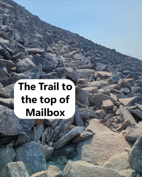
Both routes meet up for the final push to the summit. That last half mile gains 960 feet of elevation over rocky, exposed terrain.
The Washington Trail Association straight-up tells you: “Your thighs will feel the burn once you start climbing, and it won’t let up until you’re standing triumphantly next to the Mailbox.”
The worst part about mailbox is that spot when you are near the top, and break out of the trees to make the last push to the top. It is all granite steps, fully exposed and it feels straight up.
Why Smart People Keep Making Dumb Decisions
I’ve hiked Mailbox several times. I’m slow on this trail. Really slow. And I’ve done my research, packed properly, and started early.
I still got humbled every single time. Literally one of my goals in life is to hike mailbox and not be gassed when I get back to my ride.
But the problem isn’t the trail. The trail is honest about what it is. The problem is that it’s 45 minutes from downtown Seattle, it’s all over Instagram, and it’s become a “rite of passage” for locals. People show up in Crocs with a single water bottle and zero backup plan.
On a typical weekend, the trailhead parking lot has 50+ cars at any given hour. The upper lot has 40 spaces and fills by 7 a.m. That’s potentially hundreds of people on the mountain, and a significant percentage of them are woefully unprepared.
Online hiking forums have turned Mailbox into a running joke. Head over to r/Mountaineering and you’ll find people sarcastically comparing it to K2 and Mount Everest. But the jokes exist because people genuinely suffer on this climb. The proximity to civilization creates a cognitive dissonance where folks simply can’t believe a trail this close to Starbucks could actually kick their ass.
It absolutely can.
The Injuries Keep Piling Up
According to King County SAR, the most common calls involve:
- Dehydration: People underestimate how much water they need climbing 4,000 vertical feet
- Leg cramps: Often a symptom of dehydration combined with inadequate electrolytes
- Falls: The old trail is a web of exposed roots and loose rocks
- Lost after dark: Hikers start too late, move too slow, and get caught when the sun sets
In one recent mission, Seattle Mountain Rescue’s e-bike team reached a dehydrated hiker just as temperatures dropped and darkness closed in. On the way up, they encountered multiple other hikers who needed headlamps and food. King County SAR ended up assisting seven hikers total that evening.
Seven people in trouble. On one trail. In one mission.
Between Memorial Day and July 4th this year, King County SAR responded to 27 backcountry missions. Mailbox Peak, Mount Si, and Snow Lake accounted for most of the calls. All three are “Instagram-famous” hikes less than an hour from Seattle.
What Search and Rescue Actually Wants You to Know
In their Instagram post, King County SAR made their policy crystal clear: “Compassion first. Lessons second. Judgement never.”
They’re not trying to shame anyone. Accidents happen to experienced hikers too. But they are begging people to stop making easily preventable mistakes.
Here are their five specific recommendations for Mailbox Peak:
1. Bring a real headlamp.
Your phone flashlight doesn’t count. Trail nights are darker than you think, batteries die faster in the cold, and when your phone dies you lose your navigation AND your emergency contact. King County SAR has responded to multiple missions because someone’s phone died and left them stranded in the dark.
2. Pack the 10 Essentials.
Navigation, sun protection, insulation, illumination, first-aid supplies, fire, repair kit, nutrition, hydration, and emergency shelter. If you get injured, these items keep you alive while the volunteer teams hike 3,000+ vertical feet to reach you.
3. Choose hikes that match your current fitness level.
Especially early in the season when you haven’t been on a trail in months. Mailbox Peak is not the place to discover you’re out of shape. Work up to it with Rattlesnake Ledge or Poo Poo Point first.
4. Don’t count on cell service.
The trail has decent coverage in most spots, but “most” isn’t “all.” Download your offline maps before you leave the parking lot. If you can’t call for help, you need to be able to navigate yourself out.
ALWAYS carry a personal locator beacon.
It doesn’t matter if the trail is 3 hours from civilization or an hour out of town. Cell phones don’t work, they run out of batteries, and so on. A personal locator beacon will direct rescuers right to you. Standalone ones aren’t inexpensive, but they are cheap compared to being stranded deep in the woods with your life on the line.
5. Wear actual hiking shoes.
I hike it in Luna sandals, but I’ve been hiking in them for years. If you want to take on Mailbox, wear good shoes. Don’t hike 4,000 vertical feet in Crocs. Or flip-flops. Or fashion sneakers with zero ankle support. Just don’t.
My Honest Take
The first time I hiked Mailbox, I thought I was prepared. I wasn’t.
The second time, I knew what I was getting into and still got my butt kicked.
Unless you are young and fit, this isn’t a trail you master on attempt one.
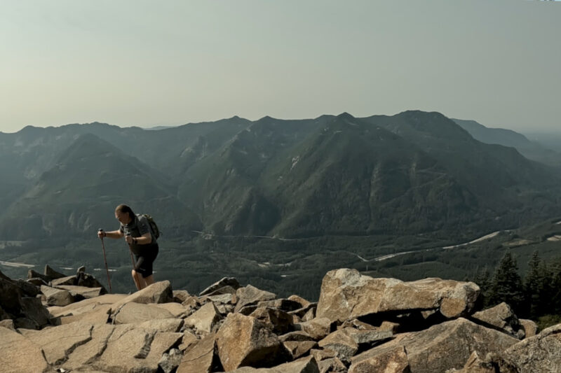
The views from the top are absolutely worth the suffering (provided it isn’t cloudy or smoky. Mount Rainier dominates the skyline like it’s trying to make up for every terrible step you just took. The Middle Fork Valley spreads out below you in layers of green. And that ridiculous mailbox actually makes you grin after all that pain.
But you’ve got to be brutally honest with yourself about whether you’re ready.
Worth It Factor
Yes, but only if you earn it.
Don’t make this your first “hard” hike. Build up to it. Get comfortable with sustained elevation gain on friendlier trails. Figure out how much water you actually need when you’re climbing straight up for hours. Test your gear. Know your pace.
And for the love of all that’s holy, bring a headlamp. The volunteer SAR teams are heroic, but they shouldn’t have to risk their own safety hiking up 4,000 feet in the dark because you thought for sure that you would be down by dark, when you start hiking at noon.
These are volunteer teams. They don’t charge for rescues. They show up at 4 p.m. on a Saturday and hike until midnight to bring you down safely. The least you can do is prepare properly so they can spend their weekends with their families instead of hauling your dehydrated ass off a mountain.
Have you hiked Mailbox Peak? Got survival stories or hard-won wisdom to share? Drop them in the comments below or email me at cliff@10toestravel.com.