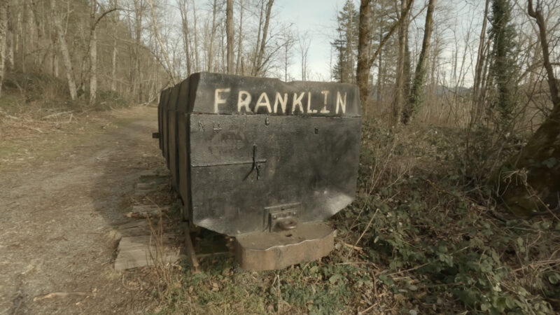
Every photo you’ve seen of Franklin Ghost Town is the mine cart. That one rusty, photogenic mine cart that makes the whole place look moody and atmospheric. The rest of the hike looks considerably less dramatic. The history, though — that part earns the drive.
What Franklin Ghost Town Actually Is
Let’s just get this out of the way upfront, because every other hiking site on the internet is going to describe Franklin as “haunting” and “atmospheric.” I’d describe it as a gravel road through the woods with some interesting stuff to look at if you know what you’re looking at.
Here’s what you actually get:
- A rusty coal mine cart at the trailhead (legitimately cool, the visual highlight of the whole thing)
- A sealed mine shaft with a concrete cap and a grate over it
- Some concrete foundations half-buried in vegetation
- The remnants of a powerhouse structure
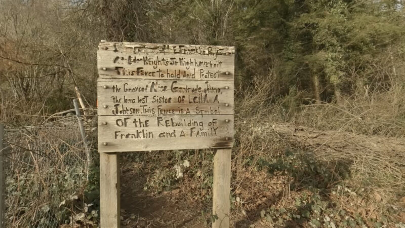
- A small overgrown cemetery with weathered headstones
That’s the ghost town. There were once more than 1,100 people living here — homes, a hotel, a school, two saloons. The forest took all of it back. What’s left is rubble with good stories attached.
Which brings us to the reason you should actually go.
The History Is Where This Gets Interesting
Most people visit Franklin and learn roughly this: coal mining town, 1880s, mine fire, everybody left. That’s the bumper sticker version.
The full version is considerably darker.
The Company Pulled a Fast One (1891)
In May 1891, the Oregon Improvement Company recruited African American workers from Missouri, Illinois, Kentucky, and Tennessee with offers of good-paying jobs and free transportation. It wasn’t until their train arrived at Franklin that the workers realized they were being brought in as strikebreakers.
Their passage from the Midwest had been arranged under a veil of secrecy, specifically to keep the plan from being discovered by labor activists. Over 500 men, many of them skilled miners, marched into Franklin under cover of darkness to find barbed wire fences and armed guards waiting for them.
The white miners who’d been on strike didn’t direct their anger at the company that deceived everyone involved. They directed it at the new arrivals. The local paper eventually coined the violence that followed “The Day of Black Terror.”
Riots broke out across Franklin and neighboring mining towns. The National Guard was called in to restore order. The company won. The strike was broken. The Black workers stayed and went to work in the mine.
Three years later, 37 of those miners were dead.
The Fire (1894)
On August 24, 1894, thirty-seven miners suffocated due to a fire in the mine that appeared to have been intentionally started.
The situation was made worse by a series of errors — a worker who shut off the mine’s air supply fans at a critical moment, and another who opened a door that worsened the smoke exposure. The victims were trapped 700 feet underground on the 6th level north.
A coroner’s jury ruled the fire was caused by “party or parties unknown” who “did willfully, knowingly and maliciously cause said fire.” In other words: arson. Nobody was ever charged.
The mine continued to operate for nearly 25 years after the disaster, but by 1919 coal mining in the area had all but ceased. With no jobs left, most of Franklin’s residents abandoned the town. The forest moved in and got to work.
That cemetery you’ll walk past near the end of the trail? Those headstones belong to real people who lived through all of that, or didn’t.
The Hike Itself (The Boring Part)
Here’s the practical stuff.
Distance: 2 miles out-and-back Elevation gain: 232 feet Difficulty: Easy. Your grandma could do this if she’s reasonably mobile. Time: 45 minutes to an hour, more if you poke around Dogs: Yes, on leash Restrooms: No. Handle that in Auburn or Black Diamond before you arrive.
The trail follows a gentle old railroad grade from the trailhead up to the coal cart, then continues to the sealed mine shaft, powerhouse foundation, and cemetery. The first stretch is wide, graveled, and flat. The trail gets narrower and brushier as you push toward the cemetery — long pants are a good call in any season, because the blackberries are not playing around.
Trail signage is minimal. Download the AllTrails map before you leave, because data out here can be spotty and there are enough forks to get you turned around if you’re not paying attention.
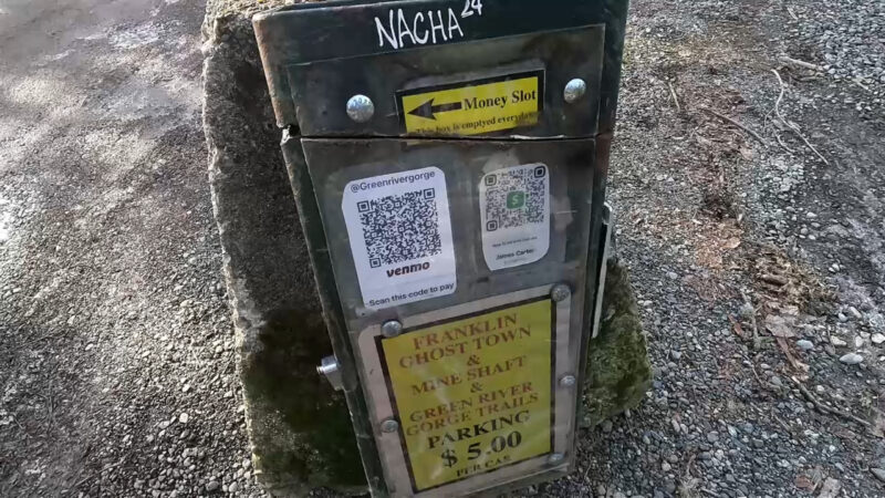
Parking: There’s a large mud lot with an honor-system pay box. The charge is $5 per vehicle. Cash or CashApp. Some people say you can park up along the side of the road, but I wouldn’t suggest it.
Getting there from Auburn: Head south on WA-169 toward Black Diamond. Follow SE Green River Gorge Road toward the trailhead. Google Maps works okay for this one.
What to Actually Look For
Most people walk past the good stuff because they don’t know what they’re looking at. Here’s what to slow down for:
The coal cart — You’ll see it right at the trail fork. This is the most photogenic thing here and the image that fools people into thinking the whole hike looks like this. It doesn’t. Enjoy it.
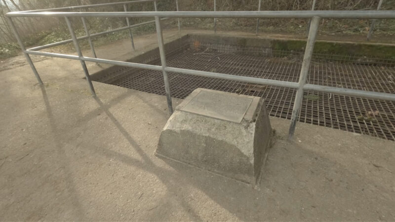
The mine shaft — The concrete cap and grate were placed over the shaft by Washington State Parks in 1994. The shaft runs over 1,300 feet deep. Drop a rock in if you feel like getting a sense of scale. It’s a long way down.
The powerhouse foundation — Just concrete walls reclaimed by ferns. But if you know that this is where the operation that employed over a thousand people was powered, it hits different.
The cemetery — This is the part that earns the visit. The headstones are weathered and some are hard to read, but they’re real. People who lived and worked here during all of that history are buried in this hillside. Take a minute.
Is It Worth the Drive?
Yes, but not for the reason you think going in.
This isn’t a scenic hike. There are no views to speak of, no dramatic terrain, nothing that’s going to make your Instagram look like you did something impressive. The trail is easy enough that a toddler can handle it, which should tell you something about the physical challenge involved.
What it is, is a place where something real happened. Over the course of a relatively small time, a town was built in the wilderness, people lived their lives and then the winds of fate changed and the town virtually vanished. Maybe stop and consider how little is left after 100 years, and how little you could see if people weren’t making at least some attempt to keep the site clear.
Come with that in mind and you’ll leave with something worth thinking about. Come expecting Deadwood and you’ll be back in your car wondering why you made the drive.
Make a Day of It
The Franklin Ghost Town hike is a bit of a nothing burger, but pairs naturally with a couple of nearby stops:
Black Diamond Bakery — About 10 minutes back toward town. Old-school bakery, great for a post-hike slice of pie. Cash-friendly, no pretension.
Black Diamond Museum – Just down the street from the Black Diamond Bakery, this small museum has some great insights into the history of the area and the rise and fall of coal mining in Washington state.
Union Stump & The Black Diamond Graveyard – Located at the intersection of Roberts Road and Morgan Street, the Union Stump is a great quick stop to give one last shot of mining history into your day. As for the graveyard next door, it is supposed to be haunted as well.
Flaming Geyser State Park — About 15 minutes away on the same Green River corridor. Different vibe: actual trails, Green River access, kayaking. The “flaming geyser” is also a disappointment in its own right, which I’ll save for another post. The park itself is genuinely good with lots of river access and a cool entrance bridge.
Green River Gorge swimming hole — Accessible from the same parking area as Franklin. Worth exploring if you’re out in warmer months.
The Quick Reference
| Distance | 2 miles out-and-back |
| Elevation Gain | 232 feet |
| Difficulty | Easy |
| Time | 45–60 minutes |
| Parking | $5/vehicle, honor system |
| Dogs | Yes, on leash |
| Restrooms | No — plan ahead |
| Best Seasons | Year-round; muddy in winter |
Ever hiked Franklin and come away with something to say about it? Drop it in the comments. And if you’ve got a ghost town or dark history hike somewhere in the PNW that you think deserves more attention, shoot me a note at cliff@10toestravel.com. I’m always looking for the next one.